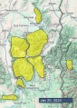
Advisory Archive

6-8” new snow around Bozeman and Big Sky
2-3” around West Yellowstone, Island Park and Cooke City
Most of the new snow fell during the day yesterday, but it is snowing again early this morning. Snow will wrap up this morning without much additional accumulation. Temperatures this morning are in the single digits above and below 0 F. Winds are 5-15 mph out of the north and west with gusts of 20-40 mph.
Today will be mostly sunny, with high temperatures in the single digits and teens F. Winds will remain northerly and light in our northern regions and moderate further south.
High pressure is settling in for the next week, so don’t expect any more new snow for a while.


It has started to snow this morning, but only a dusting has accumulated so far. Temperatures are in the single digits and teens F. Winds are 20-25 mph out of the south and west, with gusts of 30-50 mph.
Temperatures won’t rise much today, with high temperatures being in the single digits and teens F. Winds will back off a bit and shift to be more out of northwest and north. By tomorrow morning, 2-5” of snow will fall around Bozeman and Big Sky, with the bulk of that coming this morning. 1-3” will fall near West Yellowstone, Island Park, and Cooke City.


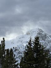

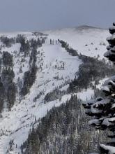
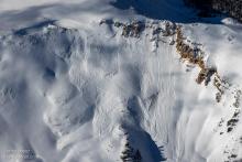
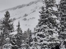
Yesterday’s cloudy skies dropped another inch or two of snow mostly in mountains near Bozeman, Big Sky, and Cooke City. Near the top of Bridger Bowl, the storm total from late Tuesday evening through Wednesday was 16 inches (0.25 inches of SWE) of the lightest snow possible, almost 99% air.
Clear skies this morning allowed temperatures to drop to almost 0 degrees F in most areas. Winds are blowing 10 mph from the NW with some higher wind speeds on Lone Mountain near Big Sky. In the Bridger Range, temps range from 5-10 degrees F, and winds are gusting 20-30 mph at all elevations.
Clouds will increase today as a trough of low pressure (aka a “storm”) drops into Montana from Canada. Temperatures should rise into the teens F, and winds should increase and blow from the W 15 mph with gusts 30-40 mph. The strongest winds of 60-70 mph will be further north along the Rocky Mountain Front. Snow should start falling tomorrow morning and there should be 3-5 inches of new snow by Saturday

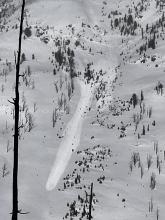

A large ridge of high pressure parked over the Pacific continues to bring strong winds, cold air, and some snow from Canada into the forecast area. Yesterday strong winds gusting 50-60 mph blew generally from the west (some WSW and some WNW).
This morning at 6 a.m. it's snowing with 6 inches near the Ridge at Bridger Bowl, 2-3 inches near Cooke City, and a trace to 1 inch in most other places. Winds eased since yesterday and are blowing from the NW 10-15 mph gusting to 30 mph. Temperatures are in the single digits F.
Today mostly during the morning hours another few inches should fall in the mountains near Bozeman, Big Sky and maybe Cooke City. Snowfall should end mid-morning but clouds will linger over most areas. Winds from the NW should ease by afternoon but continue bringing cold air. High temperatures will only rise a little bit reaching 10 deg or the low teens F at the most.

This morning, mountain temperatures range from –11 F on Lionhead Ridge to a balmy +13 F on Flanders Mountain in the Northern Gallatin Range. Winds are 15-30 mph from the southwest through the northwest, and there is no new snow.
Today, high temperatures will be 5-10 degrees F near Island Park, West Yellowstone and Cooke City, with teens to low 20s F across the rest of the forecast area. Winds will be 10-25 mph from the west and southwest. Snowfall overnight will bring a trace to 1” to the mountains near West Yellowstone, Big Sky and Bozeman and 2” to the mountains near Cooke City.


Yesterday the Bridger Range got 3-4” of snow with 1” in Hyalite and none elsewhere. This morning, temperatures are -25 to -15 F, and wind is out of the west, northwest and north at 15-25 mph with gusts of 30-40 mph. Today, under mostly clear skies, temperatures will reach single digits above zero F, and wind will be from the west and northwest at 5-15 mph with gusts of 20-25 mph. The next chance for noteable snowfall is at the end of the week.

Since yesterday morning, the Bridger Range and Hyalite got up to 1” of new snow, and none fell elsewhere. Wind has been out of the northwest and west at 10-15 mph with gusts of 20-30 mph. Temperatures are single digits above and below zero F.
Today temperatures will be single digits above zero before dropping to negative teens to -20s F overnight. Wind will remain light to moderate from the north and west. Skies will be mostly cloudy with light snow showers during the day. Snowfall will favor mountains near Bozeman, Big Sky and Cooke City with 2-5” of low density snow, and less than 1” is expected elsewhere.


There are 3-5” of new snow in the Madison and Gallatin Ranges (most of which fell yesterday morning) and 1” elsewhere. Winds are 10-15 mph out of the north and west, with gusts of 20-30 mph. Temperatures are in the negative single digits F.
A chilly, mostly cloudy day is on tap. High temperatures will be in the positive single digits F at best and may stay in the negatives in some places. Winds will be light to moderate and westerly. Snow showers are possible throughout today and tonight. This won’t be much accumulation - a trace in most places and maybe an inch or two around Cooke City.

There is a trace to an inch of new snow and it’s snowing lightly this morning. Winds blew 25-35 mph, gusting to 50-60 mph, out of the west around Bozeman and Big Sky yesterday, backing off a little overnight. Winds are 10-20 mph with gusts to 30 mph around West Yellowstone, Island Park and Cooke City. Winds today will be moderate, shifting to the northwest.
Temperatures are in the teens and 20s F this morning. Temperatures today will only rise a few degrees before they begin to fall as a cold front moves through the area.
Light snowfall will continue today and tonight, with 1-3” accumulating by tomorrow morning.
Temperatures will be frigid through the long weekend, with high temperatures in the single digits above or below 0 F.


Yesterday high temperatures reached the low to mid 30s F in most areas under sunny skies. Snow on many sunny slopes became a little damp
This morning, temperatures are 5-7 degrees warmer than yesterday morning. Winds are blowing 15-20 mph gusting to 30 from the W and SW, except near Cooke City with light winds from the NW.
Today should be another warm one with sunny skies and a few high clouds. Temperatures should easily climb above freezing into the 30s F again. It’ll be breezy with winds from the W and SW continuing 15-20 mph gusting to 30.
Get ready for a big change in the weather. It cools off tomorrow with some snow falling into Saturday (only a few inches). On Saturday, the jet stream comes straight down from the north bringing some of the coldest air of the season with mountain temperatures well below 0 F.