Advisory Archive
This morning, temperatures are in the single digits F with 5-20 mph winds from the east to south, except in Cooke City where they are from the northeast. The Bridger Range received 11” of fresh snow with 2-4” everywhere else. Today, temperatures will be in the teens to 20s F, the wind will shift back to the southwest to west later this morning at 5-15 mph and the mountains will receive 3-6” of snow.


Since yesterday morning, the mountains near West Yellowstone received 7-9” of new snow, near Big Sky and Cooke City received 2-3”, and 1” fell near Bozeman. This morning, temperatures are single digits to teens F, and wind is south-southeast at 5-10 mph with gusts of 15-20 mph. In the Bridger Range, east wind is 25 mph with gusts to 45 mph. Today, temperatures will reach high teens to low 20s F, south-southeast wind will shift to southwest at 10-25 mph, and snow showers could deliver 3-5” by this evening.

Since yesterday morning the mountains near Bozeman and Big Sky received 3-6” of low density snow, and near Cooke City and West Yellowstone received 1-2”. This morning, temperatures range from zero to low teens F, and wind is out of the southwest at 10-15 mph with gusts of 20-30 mph. Today temperatures will reach low 20s F with south-southwest wind at 10-30 mph. Snow showers could deliver 1-3” by this afternoon near Cooke City and West Yellowstone, and by morning an additional 2-3” is possible throughout the forecast area. More snow is expected tomorrow.


At 5 a.m. there is 1” of new snow in Hyalite, 3-4” in Big Sky to Lionhead, and 1” in Cooke City. Wind is from the W-SW averaging 15-20 mph with gusts of 38 mph (58 in the Bridger Range). Mountain temperatures are in the low teens under cloudy skies and scattered snow showers. Wind will continue today, temperatures will reach the high teens and snowfall will drop 1-2” during the day.
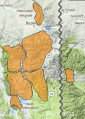
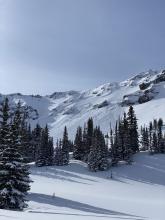
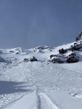
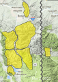
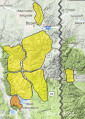
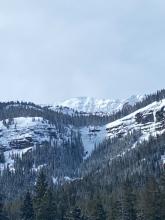
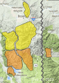
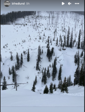
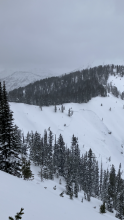
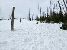
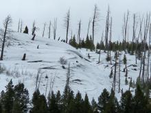
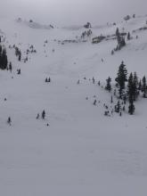
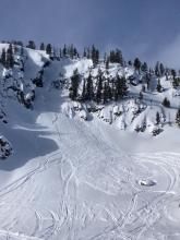
COOKE CITY
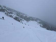
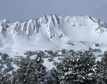
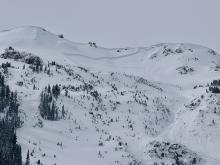
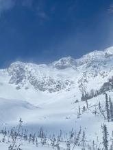
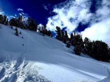
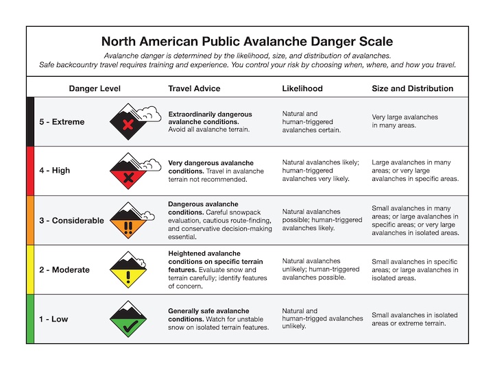
UPDATE: We are raising the avalanche danger in Cooke City to CONSIDERABLE.
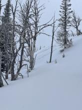
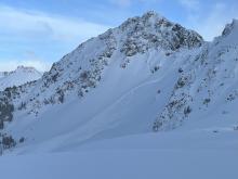
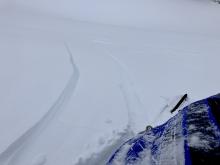
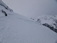
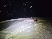
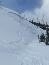
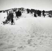
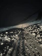
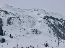
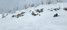
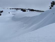
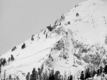
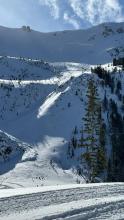
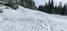
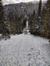
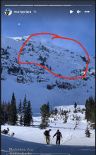
In the last 12-24 hours there was a skier-triggered avalanche and a natural avalanche at Daisy Pass (observation and photo). The natural slide was found by the groomer on the road near the pass. With only an inch of new snow and moderate winds the snowpack was not expected to avalanche. I was wrong. Our uncertainty on what exactly is going on is high. Cooke City had many large avalanches break into Tuesday. We are unsure what layer these slides are breaking on. My advice is to stay off of avalanche terrain. Natural and human-triggered slides are likely.


Yesterday, 1-2” fell with 3” at Big Sky. Wind is W-NW at 30-50 mph in the Bridger Range and 10-20 mph with gusts of 38 mph everywhere else. Temperatures are in the high single digits this morning and will reach into the 20s F today as wind blows strong from the W at 20-40 mph in the north and 10-20 mph in the south. Expect mostly cloudy skies today and snowfall tonight bringing 1-2” by morning.
This morning, temperatures are in the single digits F. The winds dropped off and are currently 5-15 mph from the southwest to the southeast. Cooke City and West Yellowstone received 3-5” of new snow, with a trace to an inch around Bozeman and Big Sky. Today, temperatures will be around 20 degrees F with 5-10 mph winds working around the compass. Cooke City and West Yellowstone will receive 1-3” of snow by morning, with a trace to an inch near Bozeman and Big Sky.


This morning there is 2-4” of new snow near West Yellowstone and Cooke City and an inch near Bozeman and Big Sky. Temperatures are in the single digits to teens F and 10-25 mph winds from the south to west. Today, snow will continue to favor the mountains around West Yellowstone and Cooke City with 3-6” by tomorrow morning. The mountains around Bozeman and Big Sky will get 1-2”. Temperatures will be in the teens to 20s F with 15-25 mph wind from the southwest to west.


This morning there is 5-6” of new snow near Cooke City, West Yellowstone and Big Sky, and 2-3” near Bozeman. Temperatures are single digits to teens F and wind is west-southwest at 15-25 mph with gusts of 35-45 mph. Today, temperatures will reach high teens to mid-20s F, and wind will be west-southwest at 15-30 mph. Near West Yellowstone and Cooke City could get 2-4” of snow today and tonight with a trace to an inch elsewhere, and more snow expected tomorrow.


Yesterday morning the mountains near Cooke City and West Yellowstone got 1-2” of snow, and elsewhere got none over the last 24 hours. This morning, temperatures are teens to 20s F, and wind is out of the southwest at 15-35 mph with gusts of 35-80 mph. Today, temperatures will reach high 20s to low 30s F, and wind will be southwest at 15-30 mph with gusts to 40 mph. Snow will begin this morning near West Yellowstone and later elsewhere. By tomorrow morning the mountains could have 3-5” of new snow.


The mountains near Cooke City and West Yellowstone have 3-4” of new snow, and elsewhere did not receive any. Temperatures are singles to teens F and wind is west-southwest at 20-30 mph with gusts of 45-60 mph. Today will be partly sunny with temperatures rising to mid-20s and low 30s F, and strong southwest wind will continue. The next chance for snow is tomorrow morning.