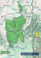
Advisory Archive
This morning, temperatures are inverted, with mountain temperatures (20s to low 30s F) warmer than valley temps (as low as 6 F in West Yellowstone). Winds are 5-15 mph out of the west and northwest with gusts up to 30 mph. There is no new snow.
Today, skies will be sunny, winds moderate out of the west, and temperatures will rise into the 30s F.
Snowfall is expected to begin tomorrow (Saturday) night.


This morning under clear skies, temps are mostly in the upper 20s F, and winds from the W & NW are averaging 5-10 mph with gusts up to 20 mph.
Today will have more warm beautiful weather with mild temps rising into the low to mid 30s F at upper elevations. Winds will be decreasing and barely blowing by afternoon.
This weekend a trough of low pressure will descend over Montana bringing cold air and snowfall on Sunday. At the moment, forecast models are only showing brief ridging (aka warm & dry weather) in the middle of next week followed by a series of troughs (aka storms) rolling across the western U.S. The main point is that there are no large ridges of high pressure in the long term forecast which is promising.

Weather this morning and for today is generally a repeat of yesterday. Temperatures this morning range from the mid 20s to low 30s F. Winds from the NW are blowing 10-15 mph gusting to 30 mph.
Today high temperatures will range from low 30s to low 40s F depending on elevation. Winds will continue from the NW but will be decreasing. Looking ahead, the ridge of high pressure creating dry and warm conditions breaks down this weekend and snowfall should return on Sunday.

At 4am temperatures are near or above freezing (30-34 F) at ridgeline weather stations and mid-20s F in most valleys with 46 F at the base of Bridger, and mids-20s F in Cooke City. Wind has been moderate out of the west at 10-15 mph with gusts of 20-35 mph. Today, skies will be clear with temperatures in the mid-40s near Bozeman and Big Sky and high 30s F near West Yellowstone, Island Park and Cooke City. Wind will be out of the west at 5-15 mph with a few moderate gusts. The rest of the week looks similar with a slight cooling trend, and the next chance for snow is this weekend.


This morning, mountain temperatures are near 30 degrees F in the northern forecast area and around 20 degrees F in West Yellowstone, Island Park and Cooke City. The winds are 5-15 mph from the west to the north.
Today, high temperatures around Bozeman and Big Sky will reach 40 F, with cooler temperatures in the southern portions of the advisory area. Winds will be 5-15 mph from the west to southwest, and skies will be mostly sunny.


This morning, mountain temperatures are in the teens to 20s F, and the mountains around Bozeman and Cooke City squeezed an inch of snow out of the lingering flurries.
- Mountain winds near Bozeman and Big Sky - 15-20 mph with gusts to 45 mph from the west
- Winds near West Yellowstone, Island Park and Cooke City - 5-15 mph, gusts of 30 mph from the west to the north.
Today's high temperatures will be in the 20s to 30s F under mostly sunny skies, with 5-15 mph winds from the west to the southwest.

Light snow showers overnight will end this morning without significant accumulations and clouds will decrease through the day. Winds have been moderate out of the west and will continue similarly today. High temperatures will be in the teens and 20s F. No snow is expected until at least mid-week.
No snow has accumulated since our last update on Wednesday. Winds have been out of the west at 10-20 mph with gusts of 15-35 mph. Temperatures this morning are single digits to teens F. Cloudy skies this morning will clear during the day with high temperatures reaching the teens and 20s F. Wind will be 10-20 mph out of the west and southwest. No snowfall is expected.

New snow totals since our last update on Monday are:
0.2-0.3" SWE / 3-6” snow - Big Sky
0.3" SWE / 3” snow - Cooke City
0.1-0.2" SWE / 1-2” snow - Bridgers, Gallatins, Southern Madison, West Yellowstone, Island Park.
Winds have been out of the southwest and northwest at 5-25 mph with gusts of 25-45 mph. Temperatures this morning are single digits to teens F. The last couple days temperatures reached mid to high 20s F. The next couple days will be mostly sunny to partly cloudy with a small chance of up to an inch of snow tonight. Temperatures will reach low to mid-20s with overnight lows in the single digits to teens F. Wind will be westerly at 10-20 mph with gusts of 25-35 mph.


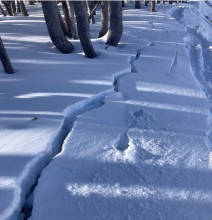
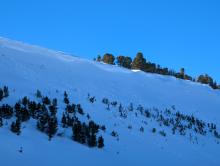
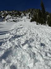
Winter is here in full force. This weekend started warm and windy on Saturday when temperatures dropped and snow fell Saturday through Sunday morning.
Snowfall: 6-10 inches of snow fell throughout the forecast area (0.3-0.9” SWE)
Winds: Strong winds from the SW gusting to 50 mph blew Saturday ahead of snowfall. They were much lighter Sunday, and increased some Monday morning blowing 10-20 gusting to 30 mph from the W.
Temperatures: They started quite warm Saturday morning, cooled quickly by Sunday, and are hovering in the teens F Monday morning.
This week: Winds from the SW will bring 2-3 inches of snow on Tuesday. By Tuesday evening, winds switch and will come from the NW keeping temperatures on the cold side this week with overnight lows in the single digits and teens F. There’s at least a chance of snow later this week but no major storms. No major winds are expected except to the north which could impact the Bridger Range the most