Advisory Archive
Since yesterday morning an inch of new snow fell in the northern mountains, 6” around West Yellowstone and 10” outside Cooke City. Under partly cloudy skies mountain temperatures are in the upper teens and winds are southwest at 10-15 mph. Today will warm into the mid 20’s and clouds will increase with light W-SW winds. Snow is expected to fall later today and this evening bringing 3-5” in the southern mountains and 2-3” in the north. Dry, cold weather is forecasted Monday through Thursday with a possible shift back to snowy weather later in the week.


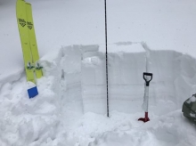
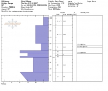
A strong winter storm has delivered heavy snow to southwest Montana. Since yesterday morning the Bridger Range has received 8-10” of new snow totaling roughly 1” of SWE. The northern Gallatin and northern Madison Ranges picked up 5-8” of new snow totaling .5” of SWE, while the mountains around West Yellowstone and Cooke City received 6-8” of dense snow totaling 1 to 1.4” of SWE. This morning it’s still snowing lightly and temperatures range from the upper teens to mid-20s F. Winds are blowing 10-20 mph out of the W-SW with gusts around Big Sky breaking 30 mph. Today, light snow will continue with an additional 1-3” possible. Highs will warm into the 20s to low 30s F and winds will continue to blow 10-20 mph out of the W-SW. Snow tapers off this afternoon and no major accumulation is expected tonight into tomorrow morning.

At 5 a.m. the mountains have 2-3” of new snow with 10-12” near Cooke City since yesterday morning. Temperatures are high 20s F, and wind is southwest at 10-20 mph with gusts of 30-40 mph. Temperatures today will be high 20s to 30s F with southwest wind at 15-20 mph. This afternoon, a cold front accompanied by stronger wind will bring heavy snowfall through morning. The mountains will get 6-8” of new snow by tomorrow morning, and intermittent heavy snow will continue through Monday.
A cold, wet weather system is currently impacting the northern ranges of the forecast area including Cooke City. Over the past twelve hours, the Bridger Range, northern Gallatin Range and mountains around Cooke City have picked up over a foot of new snow totaling more than 1” of SWE. The snowline is well defined and the mountains south of Bozeman have remained mostly dry with the exception of Big Sky which has picked up 1-2”. At 2 p.m. it’s still snowing in the mountains around Bozeman and Cooke City where another 4-6” will likely accumulate by this evening. Currently, temps are in the mid-20s to low 30s F and winds are blowing 20-40 mph out of the W-SW. Snow gradually tapers off this evening and Thursday looks to be mostly dry. This break will be short lived however as another system arrives Thursday night and Friday.
Since Saturday morning, the mountains got 8” of new snow near Cooke City, 4” in the southern Madison Range and Lionhead area, 1” in Big Sky and Hyalite, and zero in the Bridgers. Temperatures this morning are in the 20s F, and wind is westerly at 15-25 mph with gusts to 35 mph. Wind yesterday was 25-35 mph with gusts up to 77 mph at the Hyalite weather station.
Temperatures today will be 30s to low 40s F. Expect warmer, breezy, dry weather through Wednesday. The next chance for snow is Wednesday night, when the passage of a cold front could leave 1-3” of snow in the mountains and bring high temperatures on Thursday in the 30s F. After Thursday, a strong ridge of high pressure over the region will create dry weather with temperatures up to 50 F through the weekend.

At 4:30 this morning temperatures are teens to low 20s F. There is 5” of new snow near Bozeman and Big Sky with 2” near West Yellowstone and Cooke City. Wind is out of the west at 15-20 mph with gusts of 30-40 mph.
Today will be partly cloudy. Temperatures through the weekend will be in the 30s F. Wind will be west to southwest at 15-25 mph today, and will increase to 30-40 mph Sunday morning. Snow through the day on Sunday will drop 3-6” near Bozeman, Big Sky and West Yellowstone, and 7-12” near Cooke City.
At 5 a.m., 24-hour snowfall measured 1-2” in the Bridger Range, 3-6” from Bozeman to West Yellowstone and 9” outside Cooke City. At the ridgetop, winds are blowing north to west at 10-20 mph, and temperatures are in the mid 20s. The storm will exit this morning and may drop another inch of snow. High pressure moves in today with Monday and Tuesday forecasted to be unseasonably warm with temperatures touching 60F the valleys.

Cool, wet weather continues to impact southwest Montana. Overnight, the mountains around Bozeman received 3-5” of new snow totaling .3-.4” of SWE. The mountains around Big Sky and West Yellowstone picked up 1-3” of new snow totaling .1-.2” of SWE while the mountains around Cooked City got missed. At 9 a.m. mountain temps range from the upper teens to mid-20s F and winds are blowing 15-25 mph out of the W-SW. This morning, snow showers will linger in the mountains, but no real accumulation is expected. By this afternoon, skies will become partly cloudy and temps will warm into the 30s F. Winds will continue to blow 10-25 mph out of the W-SW. Another weak storm system is scheduled to impact the region Friday into Saturday. The mountains could see another 2-4” of new snow by Saturday morning.
Last night the Bridger Range picked up 6” of new snow. Other ranges got 1-2”, with the exception being West Yellowstone, which got missed. This morning mountain temperatures are in the teens and ridgetop winds are out of the west at 15-20 mph. Snowfall is tapering off and the next shot of moisture is Wednesday night which will be followed by sunny skies and seasonal temperatures.
Last night the Bridger Range picked up 6” of new snow. Other ranges got 1-2”, with the exception being West Yellowstone, which got missed. This morning mountain temperatures are in the teens and ridgetop winds are out of the west at 15-20 mph. Snowfall is tapering off and the next shot of moisture is Wednesday night which will be followed by sunny skies and seasonal temperatures.