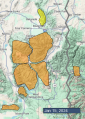
Advisory Archive
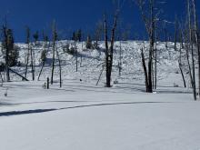
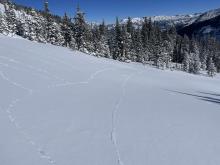
Since yesterday morning the mountains got 2-5” of new snow, except Hyalite was left out with zero. Temperatures are high 20s to low 30s F this morning. Wind has been from the southwest-west at 15-25 mph with gusts of 35-45 mph and up to 78 mph near Island Park. Today temperatures will reach low to mid-30s F and wind will be from the southwest-west at 10-15 mph with gusts to 25 mph. Light snow showers later today favor Island Park where 2-4” are possible, and 1-2” are possible elsewhere.


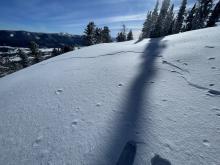
A dusting of snow fell yesterday, but no more than an inch accumulated. Winds are 5-15 mph out of the southwest to northwest with gusts of 15-30 mph. Temperatures are in the 20s and low 30s F this morning. High temperatures today will be in the 30s F. Winds today will be 5-15 mph out of the south and southwest. Skies will be partly sunny to mostly cloudy with a few snow showers possible. 2-4 inches of new snow are possible tonight near West Yellowstone and Island Park, with only a dusting expected elsewhere.


There is no new snow. Winds have been west to northwest at 10-20 mph with gusts of 30-45 mph. Temperatures this morning are in the teens and 20s F. High temperatures will be in the 20s F. Winds will be light from the west to southwest. Today will be mostly cloudy with snow showers bringing a trace to 2” of new snow by this afternoon.
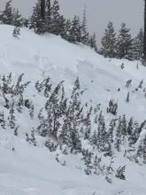
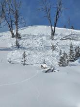
In the last 24 hours Cooke City received 10+” of new snow, 5” in the Bridger Range, and 2-3” everywhere else. West to northwest wind is averaging 20-50 mph with gusts of 75 mph. Mountain temperatures are in the single digits F around Bozeman and teens elsewhere. Snowfall has mostly ended, winds will still be strong, but lessen to 20-35 mph. Sunshine may pop through the clouds and tonight the mountains could get a trace to an inch of snow.


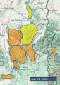
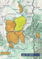
Mountain temperatures are in the single digits to teens F this morning, with 15-30 winds from the west to the south. As of 6 a.m., there is 1-2” of new snow from Big Sky through the southern portions of the advisory area, and it is just beginning to snow in the mountains near Bozeman. Today, temperatures will be in the 20s F with 15-30 mph winds from the west to southwest. By tomorrow morning, the mountains around Cooke City will receive 10-14” of new snow, with 4-8” in Island Park and West Yellowstone and 3-6” around Bozeman and Big Sky.


Mountain temperatures are in the balmy single digits above and below zero F, with west to northwest winds blowing 10-25 mph. There is no new snow. Today, temperatures will soar into the teens F. Winds will be 10-20 mph from the west to southwest, and snow will move into the area early tomorrow morning with a trace to 2” falling by daylight. Snow will continue tomorrow.


Overnight the mountains got 1-2” of low density snow. Arctic air is tightening its grip for one more day and temperatures are -5 to -25 F this morning. Wind increased overnight out of the west-northwest at 15-20 mph with gusts of 25-50 mph, and this morning wind decreased to 5-15 mph from the northwest-north. Today, temperatures will reach single digits below zero F with a few places rising slightly above zero, and wind will be north-northwest at 5-15 mph. The next chance for snow is tomorrow night.


Temperatures have skyrocketed to single digits above and below zero F. Wind has been out of the southwest and northwest at 5-15 mph with gusts of 20-35 mph. There is no new snow. Today temperatures will reach single digits above zero F in most places and struggle to break zero F in the Bridger Range. Wind will be west-northwest at 5-15 mph with gusts to 20 mph. There is a chance for 1-2” of snow overnight.


Temperatures are in the negative teens to negative 30s F this morning. Winds are 15-20 mph out of the northwest and west with gusts of 40-55 mph. There is no new snow. Today will be mostly sunny and remain cold, with highs below 0 F in most places. Winds will slacken a little and shift southwesterly. No new snow is expected.


There are 2-4” of new snow near Big Sky, West Yellowstone, Island Park, and Cooke City. The mountains around Bozeman have 1” of new snow. Winds are 10-25 mph out of the southwest and west, with gusts of 30-45 mph (and up to 75 mph near Island Park). Temperatures plummeted overnight near Bozeman into the negative teens and 20s F. Temperatures elsewhere are in the single digits this morning, but will drop into the negatives through the day. Winds will remain westerly today and be light in Bridger Range and moderate-strong elsewhere. Snowfall will finish up this morning with only an additional trace to an inch expected.