Advisory Archive
This morning, there are:
2-3” of new snow around Island Park, West Yellowstone, and Cooke City
0-1” around Bozeman and Big Sky
Winds are 15-25 mph out of the south and west, with 30-40 mph gusts. Temperatures are in the teens and 20s F (20+ degrees F warmer than yesterday morning!).
Snowfall today and tonight will bring 3-6” more new snow by tomorrow morning. Winds will remain moderate out of the south and west. High temperatures will be in the 20s F.


Cold air is on its way out, but increased winds and snowfall are on their way in.
Temperatures this morning are -5 to -13 degrees F which is five to ten degrees warmer than yesterday, but wind chills will keep things feeling quite cold. Winds increased yesterday afternoon, and are blowing 15-20 mph from the west this morning with higher gusts. Skies are clear this morning.
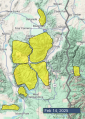
A trough of low pressure (a storm) is hitting the northern CA coast this morning and will move across Nevada and Utah today. For us, this means increasing clouds and winds from the south. The Pocatello NWS office has issued a winter storm warning for the Island Park area starting at 11am today.
Today as skies become cloudy, wind gusts will reach 30-40 mph from the south. Temperatures are supposed to rise into the mid teens F, but I bet they’ll be stubborn and remain quite cold for much of the day. By tomorrow morning, areas near Island Park and West Yellowstone could have 2-5 inches of snow while all other areas should have about an inch. More snow falls through the weekend and into next week


COLD! Temperatures are -15° F to -23° F which is colder than yesterday morning. Fortunately light winds are only blowing about 5 mph from the north.
Clear skies and sunshine will help temperatures climb to near zero F. Bone chilling winds will increase today with some gusts approaching 20 mph. Some downhill winds blew yesterday in the Bridgers and could blow again today and move some snow.
Warmer air moves into the area tomorrow morning as a deep trough of low pressure nears the California coast bringing winds from the SW. Starting Thursday night snow is in the forecast everyday for the next week. After that trough moves over the western U.S., we will be under a wet, westerly flow with no major storms but steady snowfall.


This morning, mountain temperatures are in the negative single digits to negative teens F, with light winds from the west and northwest. The mountains in Island Park got 2” of snow, with a trace to one inch elsewhere.
Today, high temperatures will be around 0 F, with 5-10 mph winds from the west through the north. Plan for a couple of cold days. The Arctic blast breaks on Thursday, and snow returns on Thursday night.


Yesterday snow favored the Bridger Range with 6” of low density snow, 1” fell in Hyalite and Big Sky, and zero to a trace near Cooke City, West Yellowstone and Island Park.
Wind was out of the west to southwest at 10-15 mph with gusts of 25-40, and this morning wind is shifting to the northwest and north at 5-15 mph. Temperatures are single digits above and below zero F.
Today, scattered cloud cover will bring a few flurries of snow with light west-northwest wind. Temperatures will reach low single digits above zero F before dropping to teens below zero overnight.
Yesterday snowfall dropped 1-3” near Cooke City, West Yellowstone and Island Park with none elsewhere. This morning temperatures are zero to single digits F. Wind has been out of the west, northwest and southwest at 10-25 mph with gusts of 25-40 mph.
Today, skies will be mostly cloudy with light snow showers, temperatures will reach single digits to teens F, and wind will be light at 10-15 mph with moderate gusts to 25 mph. By morning 1-3” of new snow is possible near Bozeman, Big Sky and Cooke City with a trace to 1” elsewhere.


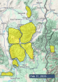
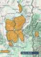
Snowfall ended yesterday afternoon with 24 hour totals of:
3-4” (0.2-0.4” Snow Water Equivalent) across most of the advisory area
7” (0.6” SWE) near Lionhead
9” (0.8 SWE) near Cooke City
This morning, temperatures are in the single digits and teens F. Winds are 10-15 mph out of the west and northwest with gusts of 30-40 mph.
Skies will be increasingly cloudier the further south you go in our advisory area. Temperatures won’t rise much, with highs remaining in the single digits and teens F. Winds will back off a bit and gusts will die down as they shift more southwesterly. A dusting to 2” of new snow will accumulate by tomorrow morning.

This morning, it’s snowing and 2-3” of new snow have accumulated so far. Winds are blowing from basically every direction on the southern half of the compass (W-SE in most areas and straight E in the Bridgers) at 15-30 mph with 25-50 mph gusts. Temperatures are generally in the teens F.
Winds will increase this morning, shifting to be consistently out of the west. High temperatures will be in the 20s F in the southern areas, but will stay steady or actually fall throughout the day in the areas around Bozeman and Big Sky. Steady snowfall, which may be heavy at times, will add up to 4-8” in most places by this evening. Cooke City will be a bit favored and may get more like 6-10”. Snowfall will end this evening.

It’s been a roller coaster of crazy weather:
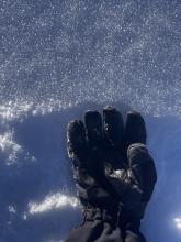
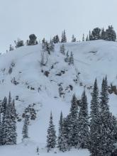
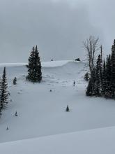
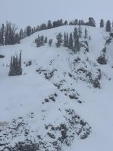
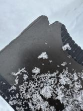
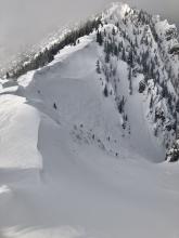
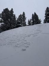
Friday (Jan 31) through late Monday brought 30” snow (3” water) to mountains near Cooke, 16-21” snow (2-2.4” water) to mountains near Island Park and West Yellowstone, and 12-20” snow (1-1.6” water) to the Bridger, Gallatin, and Madison Range. The tail end of these storms delivered a very rare coating of dust (photo) to the snowpack in all areas except the Bridgers. This dust may impact the snowpack later, but for now it indicates unusual weather.
Tuesday had temperatures well above freezing in many areas while the Gallatin Valley struggled to get above zero degrees F. Very strong winds from the south began ramping up.
Wednesday (yesterday) had continued very strong winds (gusts up to 80 mph) from the south and temperatures near freezing while many valleys had temperatures 30 degrees colder. Snow started falling yesterday and temperatures started dropping. The Bridger Range picked up 6-9” snow (0.5-0.6” water) while most other areas received 3-4” snow (0.3-0.4” water).
This morning mountain temperatures are 5-10 degrees F which are 25 degrees colder than this time yesterday. Winds aren’t as strong and are blowing more from the west 15-30 mph gusting 40-60 mph.
Today there may be a little sunshine this morning but clouds will be increasing through the day with winds decreasing. Temperatures should generally get into the mid teens F. An area of low pressure (aka a storm) will hit the west coast today and bring snowfall to our area tomorrow. There may be a few snowflakes in the air late today, and Friday should have 3-4” of snow with strong winds from the southwest mainly near West Yellowstone, Island Park, and Cooke City.
This morning, you wouldn’t believe it sitting in -5 F temperatures of Bozeman or the base of Bridger Bowl, but mountain temperatures are in the high 20s to mid-30s F. Strong winds are blowing 15-45 mph with a recent gust on Lone Mountain hitting 90 mph.
Today, mountain temperatures will drop into the teens F by this afternoon as a cold front moves through the area. Strong 25-50 mph winds from the southwest will continue most of the day. The mountains will receive 2-4” of snow this morning into early afternoon.